Moderate Risk for Severe Storms today in South Dakota. NE WY, and NW Nebraska also have great chances for strong supercells today. There is a little bit of a tornado threat today but mostly a big threat of Huge hail today. We will be chasing within the Moderate today.
Facebook and twitter has started to light up tonight that Tim Samaras, his son Paul Samaras, and Carl Young all veteran storm chasers apart of Twistex were killed in Friday's tornado in Oklahoma. This tornado was a confirmed EF3 tornado near El Reno. Tim Samaras was a great friend, a great man, one of the nicest guys you could have met. He was a very brilliant man, as well as the people who worked for him. He always had a genius idea to research weather and actually put it to practical use. He was an amazing electrical engineer with ground breaking projects that blew the storm chasing and scientific communities away at the same time. He was seriously a legend and so many are heart broken tonight.
Spotter Network is already lighting up tonight, if you are a storm chaser help keep this alive in memory of this great guy. We are very sad that this happened to one of the best people on the planet doing this. Thoughts and prayers are with their families. Please be VERY sensitive on social networking, it is the least you can do.
Yesterday a line of embedded supercells developed west of the OKC area, the setup was in place for dangerous and violent tornadoes. Many chasers from all over the country were staging in OKC for another chase day. Taking a look at this radar image you can see 3 supercells embedded within each other with 3 areas of rotation and 2 tornado warnings in place at the time. There was a lot of rain coming from each of their cores and the rain was then being ingested by the updrafts and mesocyclones of these supercells creating a rain wrapped tornado situations. These supercells were also moving quickly and erratically. Often supercells can take turns, usually to the right or more east and south. If you are trying to outrun a tornado to the south or east, it may be difficult if the cell makes a turn in that direction.
Damage in El Reno, OK and Union City, OK May 31st 2013
All of the dots on this screen are individual chasers, as you can see chasing in Oklahoma can get very congested. More and more people are wanting to take part in this activity of chasing because its thrilling and the media glorifies the "sport". The weather channel and other outlets constantly reward chasers for taking risks to get amazing video. Just yesterday one of their own chasers Mike Bettes and the Tornado Hunt Crew got themselves in a dangerous situation by positioning themselves northeast of the tornado because of the low visibility in these rain ingested cells. They realized the tornado was moving quickly and decided to get out of there, the tornado turned right for their path and they took a direct hit. Their vehicle rolled 200 yards and they got lucky with cuts and bruises.
RAW inside TWC tumbling vehicle
Ironically a couple of years ago Mike Bettes got on other chasers for taking risks and getting too close on his Open Mike series on the weather channel.
Another chaser I know Brandon Sullivan who is very experienced and knowledgeable found himself in a dangerous situation yesterday in the outer circulation of the tornado. His video has been making rounds on CNN, TWC, and many other outlets. You can watch the videos for yourself to see how lucky they were to get away without injury.
A lot of drama in the Storm Chasing community, stating that these chasers were really stupid for taking these risks, but they do it every chase. We are all in danger when we choose to drive around severe weather, I do find it funny that many of us are the pots calling the kettle black. I found myself shaking my head a bit but I also realize that I have been in similar unplanned situations. It seems when a lot of chasers dont get all the attention at the end of the day they like to make snide remarks about the others. All of us go for that video that will sell to all of the media outlets, and we all get as close as we feel comfortable but yesterday may be some lessons for everyone.
Another situation yesterday that was a disaster was the residents of the Oklahoma City area "evacuating" from the city. The interstates and highways were congested with people driving away from the weather to avoid a situation like Moore almost a couple weeks ago.
[Photo: Dick Mcgowan]
You can not do a Hurricane style evacuation during a tornado, there is simply not enough time. Not to mention that a vehicle is the worst place to be while getting hit by a tornado. People were killed in their vehicles because of this, including a mother and her baby in this car.
Waited a long time this afternoon for good storms to fire, it had a hard time trying to get going. So we messed around, petted some horses, got lunch, and finally late evening we found something worth while.
This storm popped up on radar and looked like it was organized.
Then we saw the striations in this cell, and a wall cloud that was rotating.
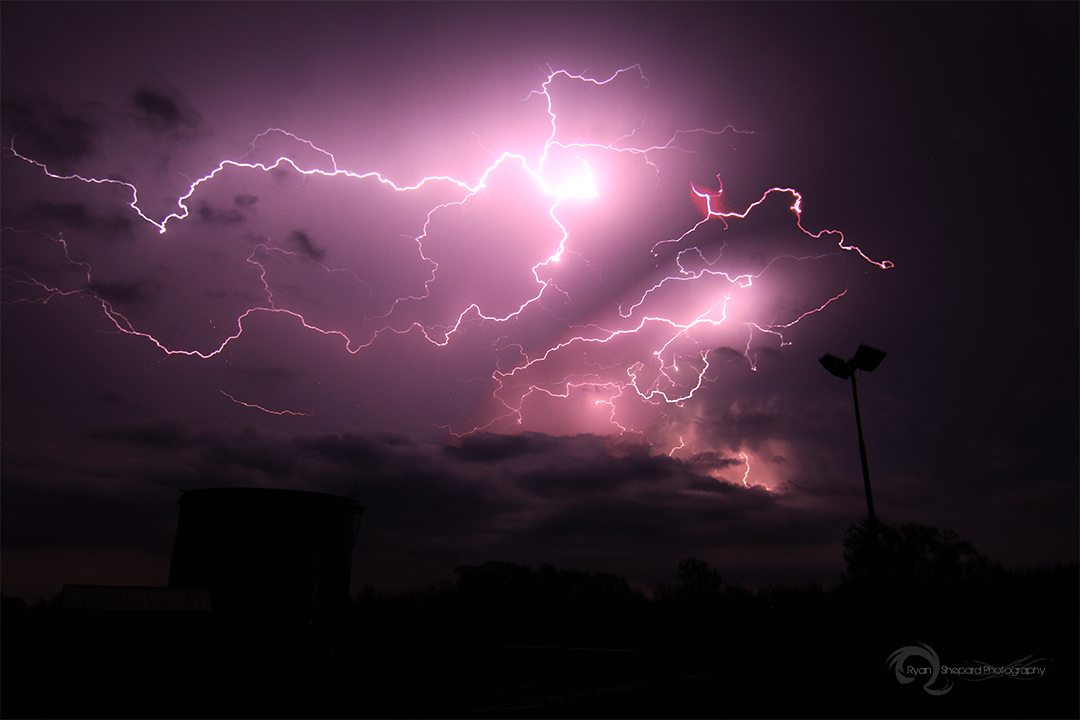
As it was getting pretty dark it re organized and created this really big bell meso, and we tried to capture some lightning with it for a while. This cell didnt move very fast and spent most of its time near Snyder, OK.